RIMAP Research: Non-Vessels
RIMAP Maritime History and Marine Archaeology Research - The Non-Vessels
© RIMAP 2019

The power house foundation at the Fort Adams marine railway. Photo by John Hoagland, © RIMAP 2012.
The interested public usually thinks of marine archaeology as the study of historic shipwrecks, and the modern media tends to focus on the advanced technology of remote sensing to find these shipwreck sites, and often shows the glamorous diving fieldwork to document what remains of them. But that is only part of the maritime story.
The the purpose of archaeology is to understand how people lived in a particular place and time, and to understand the people who built and sailed in ships, it is important to understand that all those ships were supported by many land-based economic, technological, and social systems. The shipyards that built and repaired vessels depended on the raw materials, labor, and capital that came from shore-side and inland businesses. The merchant companies and navies that sent ships on their voyages were part of much larger social institutions related to trade and political power. All of these land-based activities add important information about a particular vessel's history and they leave evidence to be discovered in that vessel's archaeological site. But more importantly, the land-based maritime network contributes to an understanding of the maritime world and the people who inhabit it.
Rhode Island has the nickname "Ocean State" because of its long dependence on ships that connected this smallest of states to the wider world. But those ships could not have been built, supplied, manned, or sent on their way without all of the land-side businesses found in near-shore and inland Rhode Island communities without immediate access to the Bay or the Sound. Therefore, all of Rhode Island has made important contributions to the colony and state's maritime activities.
The following selection of materials come from RIMAP's extensive publications about non-shipwrecks in Rhode Island. They illustrate the wide variety of Rhode Island industries and related topics that enhance the study of the state's maritime history and validate Rhode Island's claim to be the "Ocean State."
RIMAP'S NON-VESSEL RESEARCH
Pre-contact Studies:
RIMAP's marine studies are on land, too. Graphic by D.K. Abbass, © RIMAP 2011.
Given the populations that lived in Rhode Island before the coming of Europeans, it is not surprising that there are so many pre-contact sites on land in Rhode Island. However, it is probable that similar land sites will also be discovered in local waters, too. During the last glacial period, the ocean level was much lower and much of what is now covered by the Bay and the Sound was dry land. When the glaciers melted and the ocean level rose, areas that once were dry land became inundated. The people who lived where there are now only fish and lobsters may have left archaeological evidence of their presence similar to the evidence that is found on land sites. These inundated terrestrial sites will make important contributions to the understanding of the pre-contact cultures of New England.
The heavy silt that sometimes covers Rhode Island's local waters makes it difficult to discover such inundated sites, especially along the shores of what was the original river beds of Narragansett Bay and it tributaries. But the occasional find of a pre-contact artifact suggests that such sites exist. Many of RIMAP's professional archaeology team are specialists in pre-contact archaeology, and RIMAP has offered that as a specialty class, including a demonstration of how to make stone tools.
Historic Industries:
Once the Europeans arrived in Rhode Island, the early Colonial economy included farming and fishing, and the early settlers quickly developed a number of industries such as quarries and mines, smithies and forges (even for cannon) and distilleries. There were many domestic trades such as tanners, cabinetmakers, and taverns. There were marine businesses to support the ships that sailed from the colony/state in its many merchant ventures. RIMAP's historical research about the businesses in the state during the American Revolution is summarized in a number of printed Heritage Trail Guides to the historic locations of the forts, hospitals, industries, as well as the transportation and communication systems.

RI State Archaeologist Tim Ives demonstrates flint knapping to a RIMAP class. Photo by Frans Jurgens, © RIMAP 2016.
After the Revolution, Rhode Island was the home of the Industrial Revolution in America and by the 19th century, manufacturing was the state's economic strength. In the 20th century the US Navy became increasingly important and defense industries are still important local economic drivers today. All of these have contributed to the rich maritime history, and marine archaeology, of the "Ocean State."

RIMAP volunteer diver and professional archaeologist Bill Burns at the Prudence Island wharf. Photo by D.K. Abbass, © RIMAP 2012.
Portsmouth - Prudence Island Wharf:
Many of the early piers and wharves in Rhode Island are now covered over with modern construction (see Long Wharf, below). Others are abandoned and only the rubble of their foundations along the shore proclaim their earlier existence. At the northwest corner of Prudence Island was such a Colonial wharf, and it served the ferry from Warwick Neck. RIMAP's investigation of the Prudence Island wharf determined that the foundation stones are completely disturbed and that there are no visible artifacts on the site.
The RIMAP Heritage Trail Guide for selected locations for transportation and communication systems during the Revolutionary War. Graphic by D. K. Abbass, © RIMAP 2012.

The mouth of the Barrington Brickyard Canal at Nayatt Point. Photo by D.K. Abbass, © RIMAP 2003.
Barrington - Brickyard Canal:
The brickyard in Barrington was located adjacent to what is now Brickyard Pond, the borrow pit from which the clay came to make the bricks, and that has since filled with water. The brickyard was connected to Nayatt Point by this canal that served the barges that carried the bricks to Providence. From there the bricks were shipped to many East Coast cities. The brickyard ceased production in 1946, and the nearby area has since developed as a residential community. The canal is now overgrown but its debouchment into Narragansett Bay and the turning basin at Nayatt Point are still visible.
Newport - Goat Island Torpedo Station:
The US Navy ordnance development facility on Goat Island, called the Torpedo Station, was an important 19th- and early 20th-century manufacturing industry in Rhode Island, and it built 90% of all the torpedoes used in World War II. Its scope expanded to include the torpedo facility on Gould Island, and the test range to the north along the west coast of Prudence Island. By the late 20th century the Naval Undersea Warfare System in Middletown had replaced the Torpedo Station, the facility on Goat Island had been disestablished, and the island had been developed with major boating and resort facilities. Despite that change in land use on Goat Island, RIMAP has found two derelict torpedoes nearby. Although these were inert, other ordnance could still be armed and hazardous and RIMAP includes a discussion of these dangers in its volunteer training.
The US Navy Torpedo Station on Goat Island. Top - The island in 1900; Bottom - The island in 1930-1945. Both images from Wikipedia.
Newport - Fort Adams Marine Railway and Power House Foundation:

The remains of the larger Fort Adams marine railway. Photo by John Hoagland © RIMAP 2013.
The US Army occupied Fort Adams until the 1960s when most of the property was turned over to the State of Rhode Island for use as a State Park. It is generally unknown that the Army has more vessels than the Navy, but they are smaller, mainly used as transports to move men and materiel.
When the US Army occupied Fort Adams there was a shipyard on the grounds north of Fort Adams that tended to the vessels that serviced local needs. All of the buildings of the shipyard have been demolished, but there still can be seen the remains of two marine railways that serviced the Fort Adams vessels. A small marine railway was located in the boat basin to the north, enclosed by the granite walls, but the larger marine railway extends more than 400 feet from the shore eastward into Newport Harbor.

The Fort Adams US Army marine railway. Top - Aerial photo by Tom Freeman; Bottom - Site maps by John Hoagland. Combined graphic © RIMAP 2017.
The foundations of the power house are obvious, as well as the cement pilings nearest the shore. The underwater structure is made of wooden timbers that supported the rails, on which a carriage on rollers could be let down into the water, and by which an Army vessel of up to 100' could be brought out of the water for inspection and repair.

Fort Adams during a music festival: the red shows the location of the marine railway. Aerial photo from the Fort Adams website.
The RIMAP Site Manager for the Fort Adams marine railway study is John Hoagland, and the team mapped, photographed, and videotaped the timbers and associated features. The team also identified some of the marine life that finds the marine railway a congenial habitat.
RIMAP's early comparison of the railway's current construction details with the original plans housed at the Crandall Engineering Company in Boston determined that the timbers exhibited very little deterioration. However, the underwater structure was intact until 2008 when the top timbers that supported the rails were dislodged. Local boats that anchor in the area during major music festivals at Fort Adams are probably responsible for this damage, rather than malicious activities.
RIMAP archaeologists searching the area of the Block Island sewage outfall. Photo by D.K. Abbass, © RIMAP 2002.
Block Island - Sewage Outfall Survey:
Much of the archaeology done in the marine environment is not glamorous. For example, in 2002 RIMAP's professional archaeologists conducted a non-disturbance survey of the area of the Block Island sewage outfall extension prior to construction. There have been many ships lost at Block Island, and such areas of intense loss must be checked before industrial development can take place. This is sort of marine archaeology may not make an exciting discovery, but it can be important for preservation and public safety.

The historic Beavertail Light at the south end of Jamestown. Top - The original Beavertail light house before 1780; Drawing from Library of Congress. Bottom - Its remaining foundations today.
Image by Jamestown Lighthouse Assoc. Combined graphic © RIMAP 2017.
Aids to Navigation:
There were many lighthouses and other features that guided ships as they approached Rhode Island ports. Many are still in use as aids to safe navigation, and all were particularly important before the era of modern technology. RIMAP's studies, especially of the American Revolution in Rhode Island, include many such non-shipwreck sites.

RI State marine archaeologist Charlotte Taylor at the Charlestown collection of aircraft. Photo by D.K. Abbass, © RIMAP 1999.
Charlestown - Aircraft graveyard:
Archaeological method and theory can provide insights into the interpretation of what might be considered modern (not historic) materials, and some archaeologists specialize in aircraft, not shipwrecks. RIMAP's visit to a collector of naval and commercial aircraft debris (housed on 4 acres of his private property in Charlestown), illustrated how much might still be found in Rhode Island. Therefore, RIMAP's studies have included the land sites associated with local airfields and their buildings, and the many dramatic aircraft losses. RIMAP's inventories of archaeological resources include such aircraft and land sites, and of special interest is the RIMAP report to the US Navy of its cultural resources in Rhode Island.
Changes in the footprints of the land:
Marine archaeologists must also take into account how human intervention has changed the land, especially in port areas and other locations (often industrial) that are part of the marine environment. Most of Rhode Island's ports and shorelines have changed over time, and RIMAP studies have included some excellent examples. Newport's - Goat Island: The north and south ends of Goat Island have changed dramatically since Colonial times, and the adjacent waters to the south, east, and north of the island have been dredged to allow increasingly larger vessels safe access to Newport's Inner Harbor. For instance, in the 18th-century there was a spit to the north of Goat Island that was uncovered at low tide. This is where the 26 pirates were buried in 1723.

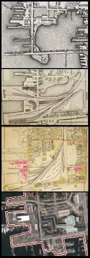
Maps show how Newport's Goat Island footprint has changed.
L-R: Blaskowitz (1777), Dripps (1860), and Google Earth. Combined graphic © RIMAP 2015.
In the 19th century a lighthouse was built at the north end of the spit, and a granite breakwater was installed to protect the steamship landing on the Newport town shore to the east. The 1938 hurricane destroyed this breakwater and it was not replaced. When the Navy dis-established its Torpedo Station on Goat Island, the buildings were razed and the former spit and breakwater were filled to create a north extension of the island to join the lighthouse. A modern hotel now sits on the landfill that covers the spit where the pirates were buried.
The original south tip of Goat Island was also a shallow spit that curled eastward along the narrow southern entrance to Newport's Inner Harbor. In the 19th century this spit was removed, and a number of large boulders that were hazards to navigation were blown up. The western shoreline of the island has been strengthened with a sea wall, and in the late 20th century the former navy piers on the eastern shore, that serviced the Torpedo Station, were developed into a major yachting facility.

RIMAP supporter Gurney's Resort, at the north end of Goat Island. Image from the Gurney's website.
RIMAP's interest is in the many historic ships known to have been lost near Goat Island, especially the transport fleet scuttled in 1778 and the Lord Sandwich ex Endeavour.® How the island has changed through time is an important part of understanding what happened to those vessels.

Warwick - Greene Island:
Greene Island, in Occupessatuxet Cove south of Warwick's Gaspee Point, has also changed dramatically over time, but from natural processes, not human intervention. As Greene Island is eroding away, the vessel there is undergoing the last stages of destruction by the forces of wind, waves, and especially winter ice. The vessel tucked near the shore is protected and what remains of her structure is stable. An understanding of the processes that direct those changes are part of RIMAP's study of these two ships.
Maps show how Warwick's Greene Island footprint has changed. Top: Blaskowitz (1777); Middle: An early US navigation chart; Below: Modern navigation chart showing 3 wrecks (only 2 still visible). Combined graphic © RIMAP 2014.2

RIMAP's "Not-the-Gaspee" project, Site RI 2218 on Greene Island. Photo by Joe McNamara © RIMAP 2016.
Newport - Long Wharf and The Cove:
The Newport Cove. L-R: Blaskowitz (1777), Newport Atlas (1876), Newport Atlas (1901), GoogleEarth (modern). Combined graphic, © RIMAP 2017.
The northeastern corner of Newport's Inner Harbor was always a center of maritime activity. In the early 18th century Long Wharf was built to connect the center of the town to Gravelly Point (now the south end of Washington Street) and to enclose the Cove. Small vessels could enter the Cove for service via a small opening in Long Wharf and larger ships stayed outside. There were many maritime businesses in buildings on the wharf, and over time the Cove began to fill in. By the mid-19th century, the center of the cove was filled enough to support the railroad that served the adjacent steamship terminal. By 1907 the Cove was completely filled in and the rail yard had expanded. This has all disappeared and the now area is heavily developed with commercial buildings and a tourist center. RIMAP's interest is in the Cove and the shoreline of Newport because of the many maritime business there and the ships they serviced. How the Cove and Newport's waterfront have changed through time are important to an understanding of that city's maritime history.
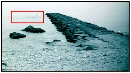
The original 18th-century cribbing used to create Long Wharf was still visible as late as the 1950s. Since Long Wharf was a center of the earliest marine trades in Newport, it is likely that deep under this now-dry land will be found materials associated with those businesses. Certainly, a 19th-century photograph shows an abandoned vessel near the area where the Newport bus terminal is now located, with ship's masts visible on the far side of Long Wharf.

Top - A derelict vessel (in the red oval) in the Cove before the area was completely filled in. Photograph, Newport Historical Society
Bottom - The same area today. Google Earth image. Combined graphic, © RIMAP 2017.
Other Overlooked Activities Necessary for Archaeological Investigations

RIMAP volunteer Butch Cormier working on ground tackle. Photo by Greg DeAscentis, © RIMAP 2004.
RIMAP has conducted many studies on land and on water, investigating shipwrecks and other historic cultural resources, and RIMAP has done it all by volunteers under the direction of professional archaeologists. What is usually overlooked in any description of these activities is how much preparation it takes to get a team and its equipment ready, and all the post-processing and interpretation of data that takes place after the exciting fieldwork. What is described in this website is only part of what must done to conduct such research, but RIMAP's mission to make these experiences available to the public is certainly a success.