RIMAP Research - The Other Vessels
SHIPWRECKS: RIMAP'S MARITIME HISTORY AND MARINE ARCHAEOLOGY RESEARCH
© RIMAP 2019
Compilation and Cover Graphic by D.K. Abbass, © RIMAP 2013
The Rhode Island Marine Archaeology Project (RIMAP) has determined that Rhode Island (the "Ocean State") has had more shipwrecks per square mile than any other state. Sail, powered, and other vessels lost in Rhode Island include pre-historic Native American craft, Colonial ships and small craft, steamships and industrial barges, the 19th century gilded age of yachting and many vessels (and aircraft) lost in the modern era. There were also Naval ships of all periods and from a number of countries lost in Rhode Island, including more than 200 during the Revolutionary War.
RIMAP has found many of these shipwreck sites by using historic document remote sensing technology, and RIMAP divers and non-divers have studied many sites using archaeological fieldwork methods. RIMAP studies are often simple preliminary investigations, some of which generated inconclusive results, but many RIMAP studies are of national and international significance, and take multiple years to complete. Continuing historical research and archaeological fieldwork indicate that there may be many more sites to be found, and that deserve similar attention.
Presentations, media events, and this website share the results of RIMAP's work with a wide audience, and RIMAP publications are available in many local and some national libraries. These include books, articles, and ephemera, most of it out of print. The publications list of this website identifies those items that are available for purchase or for free download from this website. As RIMAP's resources grow, so will public involvement in these studies expand.
A SELECTION OF SOME RIMAP SHIPWRECK PROJECTS
Royal Navy frigates at Aquidneck Island:
In August 1778, during the American Revolution, the French fleet threatened the British forces occupying Aquidneck Island.
After a week of uncertainty, on August 5, the captains of four British frigates stationed in Narragansett Bay ran their ships aground along the western shore of Aquidneck Island and set them afire so they would not fall into French hands. These frigates were the Lark, Orpheus, Cerberus, and Juno. The University of Rhode Island originally studied three of these vessel in the 1970s, during the Bi-Centennial, but that institution abandoned the project after the celebrations ended.
RIMAP raised the funds and organized the teams to investigate the current conditions of the frigates in the early 1990s. A side-scan sonar survey by Vince Capone identified potential targets as frigate sites and ground-truthing divers did non-disturbance surveys of the areas at three of those targets. RIMAP's partners for the Royal Navy frigate study were Bateaux Below Inc, of New York, the University of Rhode Island, the US Navy's Marine Demolition and Salvage Unit, and the Naval Undersea Warfare Center (NUWC) Diving and Engineering Team.
HMS Lark was lost south of Arnold's Point in Portsmouth and RIMAP's non-disturbance investigation there located an unidentified bit of structure and scattered artifacts. The remains of the Lark appear to be scattered, with isolated artifacts but no obviously integrated structure. This area is relatively isolated and during its fieldwork, RIMAP observed sport divers apparently retrieving artifacts from the area.
HMS Orpheus was lost off Melville's former US Navy fueling station in Portsmouth, and the RIMAP teams noted what may be an exposed bit of its ballast pile. Although there may be more structure to be found under the deep layer of silt in this area, RIMAP limited its work on the Orpheus to a pre-disturbance survey. However, this site deserves further investigation, especially if the Navy releases the adjacent land and it is scheduled for private development.

The red figures indicate where the three Royal Navy frigate were stationed in August 1778, and where they were lost along the western shore of Portsmouth. On this contemporary DesBarres chart, HMS Lark is a triangle; HMS Orpheus is a circle; and HMS Cerberus is a square. RIMAP graphic, © RIMAP 2017.
HMS Cerberus was purposely grounded and burned near the Middletown-Portsmouth line. Today the shore is controlled by the US Navy, but nearby in the water is a modern mussel farm. Here the RIMAP teams discovered a scattered debris field that included at least three cannon and a bit of a ballast pile. For this site, the NUWC diving engineers installed a live link from the Cerberus site to share video and communication with the National Maritime Historical Society cadets on board the replica Royal Navy frigate "HMS" Rose, anchored nearby.
The "HMS" Rose replica anchored near the site of the real Royal Navy frigate HMS Cerberus. Photo by Joseph W. Zarzynski, © RIMAP 1999.

The RIMAP-sponsored teams on board "HMS" Rose.
The fourth Royal Navy frigate was HMS Juno, lost along shore of Coddington Cove. RIMAP's remote sensing using side scan sonar and sub-bottom profile equipment suggested potential targets along the Cove's south shore, but RIMAP's ground-truthing was inconclusive. Certainly the US Navy has dredged the center of Coddington Cove to accommodate ship access to Piers I and II. Further historical research after the archaeological survey was done indicated that two British transports were also sent to join the Juno in 1778, although their fate is unknown. Therefore, is possible that RIMAP's remote sensing targets were those vessels, rather than the Royal Navy frigate. Unfortunately, increased security around Naval Station Newport has stopped all further RIMAP investigations in Coddington Cove.

In this figure, the red circle indicates the beginning and end position of HMS Juno. RIMAP graphic, © RIMAP 2017.
Barrington: There is a typical commercial barge embedded in the silt of the Barrington canal that connected a brick-making industry to Nayatt Point on Narragansett Bay. By 1897 the factory had produced 67 million bricks. but the clay pits began to fail by 1900 and as the business began to decline, properties were sold off, and by 1943 the industry had closed. When the barge was abandoned in the canal is unknown, but this vessel is representative of the many small craft used to carry such industrial output to market. The study of such modest vessels is not as glamorous as Royal Navy frigates, but such barges can illustrate and interpret how such important industries began, thrived, and eventually died.
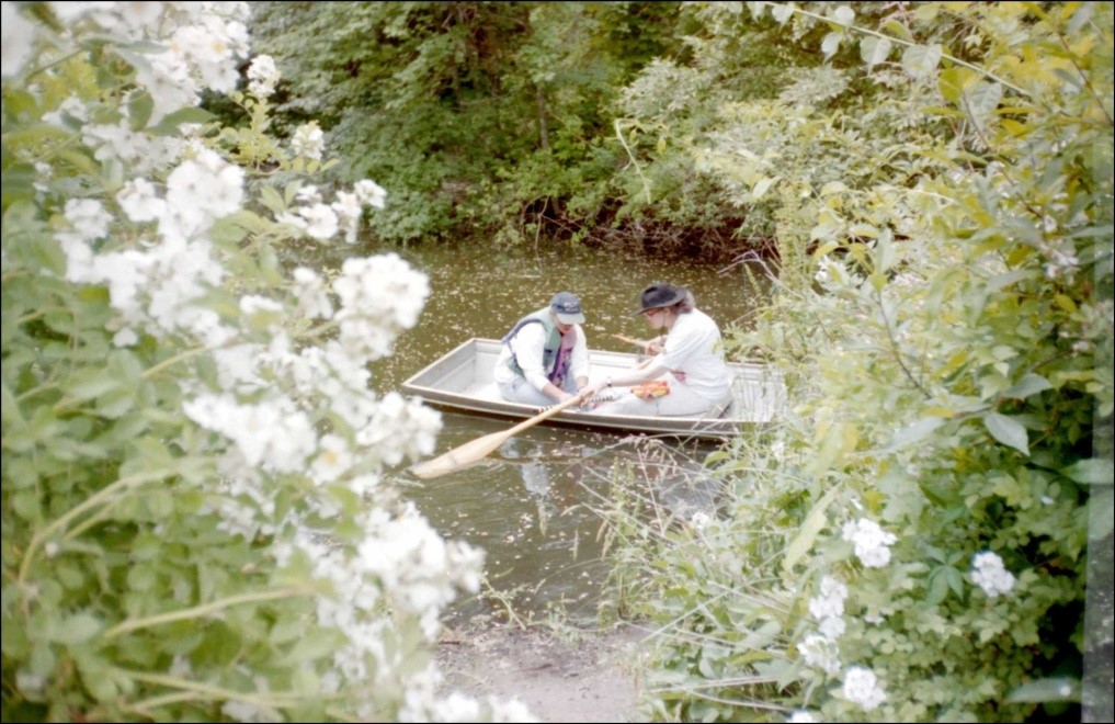
The Barrington Brickyard Barge: RIMAP volunteers Debby Dwyer and RIMAP's Principal Investigator D. K. Abbass in a skiff on the Barrington Brickyard Canal. Photograph by Charlotte Taylor, © RIMAP 1999.

Barrington: A dugout canoe was reportedly discovered by a Barrington resident in a nearby marsh. It was tentatively identified as a traditional canoe because its measurements were within typical parameters for such craft, but evidence of modern tool work suggest it was made in modern times, possibly as a Scout project. However, this is a reminder that archaeologists often investigate the evidence left by First Nations on the lands of Rhode Island and that inundated terrestrial sites may also be found in the state's local waters.
RI State Marine Archaeologist Charlotte Taylor is on board, along with the measuring tape, to show the scale of this typical dugout canoe. Photo by D.K. Abbass, © RIMAP 1997.
Bristol:
Off Independence Park lay the remains of the Steamship Empire State. This vessel burned at the pier in 1887, the owner salvaged her boilers and other usable equipment, and then left the hulk to rot. Although the pier is now long gone, the remains of the vessel are still to be seen near a red nun buoy marking the channel into Bristol's inner harbor. This site is dangerous to dive due to metal snags, abandoned fishing gear, and boat traffic.
L: The burned-out Empire State in 1888; R: RIMAP volunteer divers John Hoagland and Site Manager Debby Dwyer prepare to conduct a visual survey of what is left of the vessel in 2001. Photo by D.K. Abbass. Combined graphic © RIMAP 2019.
Shipwrecks along the Shores of Rhode Island Sound:
Many vessels have been lost along Rhode Island Sound and bits of them have become embedded in the dunes as the sand is re-deposited along the coast. RIMAP has investigated a number of these unidentified shoreside sites when they become exposed, and before they are covered again. Much of this is unidentifiable shipwreck debris, but some are large articulated structures.
The ship's structure near the Charlestown Breachway has a complex history of previous sightings, but now there appears to be nothing left that is diagnostic of this particular vessel's identity. However, RIMAP and its partner for this study, the Charlestown Historical Society, have documented its condition and observable changes when this site is intermittently revealed.

RIMAP volunteer Sandra Pulchalski documents selected details of the Charlestown Breachway wreck when it was exposed in 2012. A winter storm soon covered the vessel again. Photo by D.K. Abbass, © RIMAP 2012.

This structure was exposed on the beach just west of the entrance to Point Judith Pond. Photo by D.K. Abbass, © RIMAP 1998.
Given the number of ships known to have been lost along Rhode Island Sound, it is clear that these structures relate to such losses, even though there might be nothing diagnostic to tell which of the vessels they might have been. Although some of the structures appear to be fairly stable, RIMAP's 27 years of research has included longitudinal studies of some of these sites, especially documenting how they break up and disappear.
There are also many similar vessels known to have been lost along the south shore of Newport, facing the Sound. In 1995 a RIMAP training class mapped, sketched, and photographed the unidentified wooden barge lost in the 1930s[?] at Bailey's Beach. This vessel is exposed only on a moon low tide.
Shipwrecks Along the Shores of Narragansett Bay: RIMAP's field investigations have confirmed that there are many lost or abandoned vessels along the shores of Narragansett Bay, in its adjacent coves, and in its contributing rivers and streams. Similar to the structures found in the dunes along Rhode Island Sound, there is usually nothing left that is diagnostic of these ships' origins.

RIMAP volunteer Kathy Willis at an unidentified structure at the mouth of the Pettaquamscutt River in Narragansett. Photo by Jim Riley, © RIMAP 1997.
Of course, these shipwrecks are usually of great interest to the public, and some of the local sites have long been known to the nearby residents. One of the 19th-century vessels abandoned in Warwick's Occupessatuxet Cove is in water shallow enough at low tide for the RIMAP team to document its structure by only getting wet up to their knees. Local lore states that some time in the early 20th century a family lived in this abandoned vessel.

RIMAP's "Not the GASPEE" team measures an unidentified, abandoned ship in Warwick's Occupessatuxet Cove. Photo by Joe McNamara, © RIMAP 2015.
Newport's Outer Harbor:
During Colonial times, Newport was the third most important harbor in North America, second only to Philadelphia and Boston, and during the American Revolution many ships were scuttled in the Outer Harbor. In the 19th century Newport was a center for the rich with their magnificent yachts, and many commercial vessels were lost in the area. At the same time the Navy developed an intense presence with the Torpedo Station on Goat Island that lasted until the middle of the 20th century, and its early tests included target vessels blown up as torpedo demonstrations. RIMAP has found evidence of all of these activities in its studies of local shipwrecks in this area.
RIMAP's first remote sensing effort in Newport's Outer Harbor located two large vessels, and their targets were identified by the Greek letters, Alpha and Beta (not the ships' names). Alpha was the first target located and a recent historical study by RIMAP archaeologist Joseph W. Zarzynski has tentatively identified it as one of two landing craft that collided there in 1946. Beta is an as-yet unidentified larger vessel, but it appears to be from the late 19th-century. Features seen on Beta during RIMAP's preliminary investigation suggest that it could have been a target used in tests by the Torpedo Station on Goat Island.

ALPHA (bottom red circle) and BETA (top red circle) targets off the current north tip of Goat Island in Newport's Outer Harbor. These were two of RIMAP's earliest site studies. Base chart: NOAA online remote sensing data. Combined graphic © RIMAP 2017.
Of particular note are the vessels lost in Newport during the American Revolution, when British and Hessian troops occupied the city and controlled Aquidneck and Conanicut Islands. During the French threat in 1778, as many as 13 vessels were scuttled in Newport's Outer Harbor, and RIMAP has found many of these, too. There are many RIMAP publications about this fleet, and especially the Lord Sandwich ex Endeavour® and details of that work are found in the Endeavour section of this website.
Newport's Brenton Cove:
There are many ship structures submerged in Brenton Cove, all of which have been the subject of RIMAP's investigations. The Cove has long been a place to abandon derelict vessels, and historical sources report that the "reputed slave ship" Gem, a rum-runner named Viola, an unidentified barge, and possibly an earlier vessel, are there. RIMAP's field teams have studied four sites in Brenton cove, but the only one that can be securely identified has been the Bessie Rogers at the Beacon Rock estate pier. This site has often been mis-identified as the "slave ship Gem."

The BESSIE ROGERS in 1910, and a RIMAP diver taking her measurements in 1995. Left: Commercial post card; Right: Photo by Mershon, © RIMAP 1995. Combined graphic © RIMAP 2015.
The best known of the Brenton Cove shipwrecks is the Gem. She was built in 1851 in Baltimore, and five years later, on a return voyage from Africa to New York, she went aground on Block Island. The damaged Gem was brought to Newport where she stayed as a derelict at the Perry Mill Wharf until 1870, when she was abandoned in Brenton Cove. The Gem has long been called a slave ship, and that story resonates in Rhode Island because of the state's central role in the slave trade. However, there is no historical or archaeological evidence that the Gem had ever carried slaves; instead she carried Christian missionaries from Connecticut to Africa.
The confusion of whether or not the Gem had been a slaver is mirrored in the confusion about which site in Brenton Cove had been that particular vessel. She is most commonly identified as the ship remains at the base of the boat ramp south of the Alofsin Building. However, an 1850s view of the Cove looking toward Newport shows a derelict vessel at the same location as today's boat ramp site. Since this image long predates the Gem's arrival in Brenton Cove in 1870, the vessel at the boat ramp cannot be the Gem.

Top - The derelict ship south of the Alofsin Building at Brenton Cove in 1891, most often identified as the Gem. Photo from the Providence Public Library;
Bottom - Drawing of a vessel in the same location. Published in Mason 1854.
Combined graphic © RIMAP 2014.
RIMAP discovered a bit of structure in the shallows off the sandy beach in Brenton Cove. Along with its partner, Bateaux Below Inc. of New York, the RIMAP teams measured, mapped, photographed, and videotaped a flat slab of structure that lies there. This site has also been identified in local lore as having been part of the "slave ship Gem." There is nothing diagnostic in the wooden structure to indicate what this ship might have been, but historical evidence discovered later indicated that a barge had broken up along that shore in a storm.

The ship's structure off the sandy beach in Brenton Cove as seen in 1997. Drawing by Site Manager Joseph W. Zarzynski, © SHA 1998.
The Environmentally Sensitive Test Excavations in Brenton Cove:
In 2008 RIMAP, again partnered with New York's Bateaux Below, Inc., and conducted a series of test excavations in the channel where earlier reports suggested that the Gem had been. Marine archaeology excavations usually return the pump discharge into the water column, along with whatever particulate matter had been removed. Because of the concern that toxic materials could be disturbed by these small test excavations, RIMAP included a shore-side demonstration of how to capture the excavation discharge and return it to the Cove. This test was approved by the Coastal Resources Management Council and included allowing the discharge to settle in a large catchment basin, returning the sediment to the original test pits, and then releasing the remaining water on shore to seep through the ground before returning to the Cove. Although the test pits did not locate any shipwreck structure, the procedure proved that there is a way to manage appropriately the disturbance of toxic materials during archaeological excavations, especially at near-shore sites.

The 2008 Brenton Cove environmentally sensitive test excavations. A: The temporary catchment basin; B: The pump with divers working near shore and the discharge hose coming to the temporary catchment basin; C: The typical archaeological screen set-up. The water was first caught in a large vat where the sediment was collected to be returned to the test pits, and the water then drained to the discharge basin for further settling; D: At the end of the test, Steve Resler monitored the water as it was allowed to drain through the ground before returning to the Cove. Photos by D.K. Abbass, © RIMAP 2008.
There are many RIMAP reports, publications, and media publicity about all of this work, and much more. The work has been done by RIMAP trained volunteers and its partners, under the direction of RIMAP's professional archaeologists (who also volunteer), with very little funding, and especially no support from the Rhode Island state budget! It has been this cadre of volunteers who have generated such great RIMAP's results, and they make it clear why Rhode Island is called the "Ocean State."